Sunday, 28 October 2012

A gap in Leathermarket St - surely not.

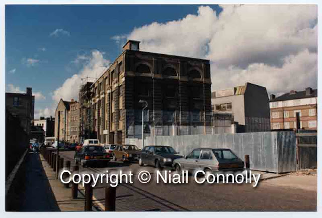
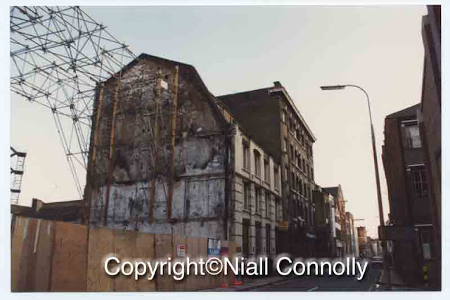
Bellway Homes were partly responsible for the re-invention of Bermondsey Street through their redevelopment of what was the British Telecom depot on Leathermarket Street. The development, designed by architects CZWG, was heavily advertised in the Evening Standard with illustrations showing a couple, in evening dress, dancing the night away.  Wishful thinking for Bermondsey in the early 1990s! However, the advertising raised Bermondsey's profile and marked the start of the mainstream development of Bermondsey. Today, the phrase 'a gap in Leathermarket St' would raise howls of protest about multi-nationals paying no tax but 'back in the day' there were other types of 'gap' in Leathermarket St.

From memory, the Bellway development was originally intended to carry on to the south, through to Long Lane. The owner of the adjacent industrial site (was the company called Dairymaid?) would not sell so the resultant Bellway scheme was rather more limited than the original vision.
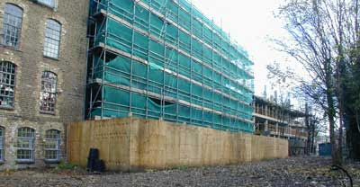
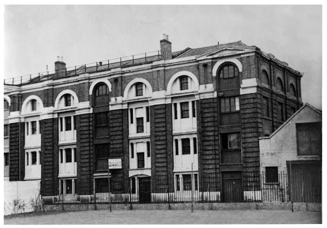
A gap in Leathermarket St!

Before the construction of 105 Bermondsey St
During the conversion of Britz Brothers/Hepburn & Gale, Long Lane.


When Blue Lion Court was another antiques warehouse.

Just before the infill at the junction of Tyers Gate and Bermondsey St


Bermondsey Wall. Now a completely impossible view.


Friday, 19 October 2012

In the Printers Yard

180 degree panorama looking west from the roof of Block K, the Printer's Yard, 175 Bermondsey Street, London SE1 Southwark
West 180, Block K. ©Niall Connolly
Standing on the terrace of Block K quite recently, I wished that I had thought to make more panoramas of Bermondsey 'back in the day'. This panorama, looking generally west from Block K, would have looked dramatically different were you able to see the same view in, say, 1998. Large chunks of what is visible today simply didn't exist even 10 years ago.

The only two 'original' buildings in this view are on the extreme edges of the image. On the far left there is McNeill's warehouse with the white glazed brickwork and, on the far right, the lower (original) part of the building was the home of Sangorski&Sutcliffe and Zaehnsdorf, one of Britain's foremost bookbinders.

Wednesday, 17 October 2012

Blue Lion Court on Long Lane

Originally a cheque clearing operation for one of the major banks, Blue Lion Court was bought by one of the 'new wave' developers in the mid 1990s. Terry Pomroy of Callington Estates was one of the earliest developers to come into Bermondsey and look to use the live/work approach to move otherwise empty buildings into development. Callington's first building was Gemini House where the initial application was rejected by the planners and then rejigged around live/work to gain planning approval.

Callington developed 4 Tanner St and also bought Blue Lion Court, achieving a successful planning approval and sold the project on.

Blue Lion Court prior to its redevelopment ©Niall Connolly


Interior view in Blue Lion Court ©Niall Connolly


Interior view in Blue Lion Court ©Niall Connolly


The panorama below was made standing on the fire escape on the north elevation of Blue Lion Court. At the time of making the panorama, none of the major developments had taken place. The Rankins building is in the process of being redeveloped as is the Guidelines Stores building but the GIFCO building is unchanged as is Bickel's Yard. In the foreground of the panorama is the RECALL building, now occupied by the White Cube Gallery.

North 180 from Lion Court ©Niall Connolly

Tuesday, 16 October 2012

Tanner St, north side, west end

The Denyer Associates drawings focussed on the Bermondsey Street Conservation Area as it was in 1979. That CA was focussed on the elevations of Bermondsey St and parts of Druid St, Whites Grounds, Tanner St, Morocco St, Tyers Gate, Lamb Walk and Grange Walk. The drawings produced by Denyer reflected the limits of the CA at that time and, as a result, leave chunks of those streets unrecorded.

In this way, Tanner St is recorded on the north side as far as Hatchers haulage yard and then there is a gap where Tanner House stands and then the drawings record the Turtle & Pearce building, leaving the elevations of Sarson's Vinegar Factory unrecorded.

This composite drawing shows Tanner St from the junction with Bermondsey St to Hatchers yard.
Elevation of the west end, north side of Tanner St, London SE1, copyright Denyer Associates
Tanner Street, north side, from Bermondsey St to Hatchers yard. Copyright©Denyer Associates


To illustrate the possible connection between 3, 5 & 7 Tanner St and the design of Telford's viaducts, the image below shows the front elevation as it would have been had 5 & 7 not been refurbished in the early 1960s. Had the building been left alone, it would probably be worthy of listing today but at least one element, 3 Tanner St, retains the original features.
Line drawing of 3, 5 & 7 Tanner St, London SE1 showing the street elevation as it would have been prior to 1960
3, 5 & 7 Tanner Street ©Niall Connolly

Bermondsey Street, east side, at Crucifix Lane.

The Denyer Associates study of 1979 generated a set of drawings of the Bermondsey St elevations at 1:50 scale. These drawings offer an accurate snap-shot of the street at that time and, in this instance, show the original street facade at 39/45 Bermondsey St, burned down in 1986.

Globe House, 39/45 Bermondsey Street, The Stage and Tempo Leatherworks, London SE1, drawn in 1979. ©Denyer Associates
Globe House, 39/45 Bermondsey Street, The Stage and Tempo Leatherworks, drawn in 1979. ©Denyer Associates

This composite image (two panels of the Denyer drawings) shows Globe House on the left, 39/45 left centre, The Stage and then Tempo Leatherworks (now the Shiva building).

The Denyer drawings didn't include the upper floors of The Stage building so I have added a section from 39/45 (in black and white) to show the roofline of this part of Bermondsey St.

Close up on Morocco St

When I was scanning and preparing the Simmons Co photographs, I noticed that the corner of Bermondsey St and Morocco St was visible behind the staff group.
Black & white image showing part of the buildings at junction of Morocco St and Bermondsey St, London SE1, photographer unknown.
Section of the Simmons staff photo. Photographer unknown.
In this image it is possible to see that the building which was to become the bank, was, at the time of the photo, a far smaller building, probably occupying 1/3rd of the site which was occupied by the (Midland) bank in later years. The detailing of the garage building in Morocco St is clearly visible to the right.

Monday, 15 October 2012

Tanner St and perambulators

Black and white image c1959 showing 5 & 7 Tanner Street, off Bermondsey St, London SE1
5&7 Tanner St as pictured from Tanner St park in 1957 prior to the building being purchased by George Hine & Sons. Photographer unknown.  
No's 3, 5 & 7 Tanner Street were built around 1838 (in a style possibly influenced by Telford who was working at St Catherine's Dock) as one building but used, until 1888, as three separate commercial premises. In 1888 the building was purchased by the Simmons Company, makers of perambulators, mail carts and stretchers. Simmons later purchased No.1 Tanner St and connected the four buildings together for different aspects of their production. No.1 Tanner St was used for painting and finishing and No.3 was the location of the forge where Simmons produced their patented carriage springs.

Simmons failed to become involved in the war effort and their production methods were overtaken by other manufacturers, notably Silver Cross. By 1952 Simmons were selling No.1 Tanner St and the company finally closed its doors in 1959. George Hine & Sons purchased and refurbished No's 5 & 7, removing the arched heads to the loading bays and the infill detailing.  No 3 remained, largely unchanged, in the Simmons family and was used in the production of military uniforms and then flags and banners till the mid-1980s.

In 1986, No.3 was purchased by Niall Connolly & Belinda Magee who undertook the first English Heritage renovation in the area. Whilst the loading cranes and chimneys had been removed by 1960, the refurbishment of No.3 saw the reconstruction of the left hand chimney (to dimensions provided by this photograph) and the reinstatement of the warehouse crane.
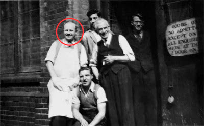


Black and white photo, Simmons Co staff, outside No1 Tanner Street, Bermondsey, London SE1. Photographer unknown.
Simmons staff pictured outside No.1 Tanner St (1950s?). Photographer unknown.
The man circled in this photograph was 'Bill' and his surname has escaped my records. When I started on the renovation of No.3 Tanner Street, a source of tools was Bickels who were leatherworkers located on Bermondsey St. In casual in conversation with the two elderly gentlemen who ran the Bickels trade counter, it transpired that Bill had worked for the Simmons Co and he had some photographs of the staff. Bill is circled in the photo above.


Black and white photo, Simmons Co staff, outside No1 Tanner Street, Bermondsey, London SE1. Photographer unknown.
Simmons staff photo before an outing. Photographer unknown.
Bill was unable to provide any specific dates for the events shown in these photographs but this is a large group photograph taken outside No.3 Tanner St, possibly in the late 1930s


Black and white photo, Simmons Co staff on company outing from Bermondsey, London SE1. Photographer unknown.
This is the staff outing pictured somewhere in the countryside. Photographer unknown. 
Again, it is difficult to date but I suspect that this photo was made in the later years of the Simmons Co as there are fewer staff in the photograph, possibly indicating the company's decline. What is of interest is the gentleman to the far right of the picture who seems to be wearing a dress.


Black and white photo, Simmons Co staff, outside No1 Tanner Street, Bermondsey, London SE1. Photographer unknown.
A group of women workers seated in an example of Simmons' product. Photographer unknown.
The Simmons Company was highly regarded in its day and Bill told me that the company had produced baby carriages for Prince Charles and Princess Anne although I have never seen confirmation of that claim. What was true was that in the late 1980s, before No.1 Tanner Street was redeveloped as offices, it was still possible to see the 'walkway' which was installed in the upper floors of that building. The baby carriages were pushed along this elevated walkway allowing the foreman to inspect the paintwork and the smooth running of the wheels and spring mechanisms.


Wednesday, 10 October 2012

Bermondsey St and Tanner St

The entrance to Royal Oak Yard, 156 Bermondsey St, London SE1 occupied by the General Iron Foundry Company GIFCO. Copyright Niall Connolly
The entrance to what was the GIFCO premises, now the entrance to Royal Oak Yard. Also known as 'The Concrete Castle', the GIFCO building was reputedly one of Britain's earliest concrete structures.

Site of 5 & 7 Tanner Street, Bermondsey, London SE1, after demolition c1987. Copyright Niall Connolly
In the foreground is 5/7 Tanner St, Zincography House, and on its right, the site of what was Hatchers Yard. Hatchers were a haulage firm and the rather crude bollards on the pavement opposite were installed to discourage Hatchers drivers from parking on the pavement. The site was soon to become Swann Court. 

39/45 Bermondsey Street, London SE1, and The Stage building after 39/45 had burned down. Copyright Niall Connolly.
One of the saddest losses on Bermondsey St was the destruction (by fire) of 39/45 Bermondsey St. That building stood immediately next to The Stage, 47 Bermondsey St, and shared the same white glazed brick facade. Unfortunately, soon after a planning application was made for the redevelopment of the site (c1986), the building caught fire, was declared a dangerous structure and pulled down.

Monday, 8 October 2012

Above Sarson's


A view made from above Sarson's Vinegar Works showing the vats in the left foreground and, in the middle distance to the left of the Sarson's chimney, you can see the wasteland that was White's Grounds, formerly known as Artillery Row. The building in the immediate foreground was a pub but, for the life of me, I can't remember its name.


This is a view of the buildings on the corner of Tanner St and Tower Bridge Road, where I made the 'high' view at the top of the page. I must have made the views of Sarson's from the roofs to the right of the right hand chimney stacks.

Saturday, 6 October 2012

Breton House, Snowsfields, Tanner St and St Thomas St

Breton House, The Grange near Abbey St. Canary Wharf in the distance. Copyright Niall Connolly
This block, and blocks like it, are quite fascinating. Why? Because, like the Lloyds Building, some of their inner workings are visible from the outside. In this case, its the staircase and the rubbish chute that is open to the world, like a cut-away drawing from The Eagle. And the light helps.


Walter Coles Polythene Bags - manufacturing in Tanner St. Copyright Niall Connolly.


The junction of Snowsfields and St Thomas St. In the background is the control box for London Bridge Station.
Copyright Niall Connolly

John Adams Printers, No.4 Tanner St, before it gained an additional floor. Copyright Niall Connolly.

The Printers Yard, GIFCO, Sarsons and Tyers Gate

The view across the Printers Yard (175 Bermondsey St) after the demolition of the Bickels buildings, with Scott Colour in the foreground and the Rankins Building in the middle distance to the left. Copyright Niall Connolly


A ground level view of the Printers Yard after the demolition of Bickels. Copyright Niall Connolly


The rear elevation of the General Iron Foundry Company (GIFCO) building with the archway leading to Royal Oak Yard. Copyright Niall Connolly.


High level view looking down into the Sarsons Vinegar Works from the east side of Tower Bridge Rd.
Copyright Niall Connolly

Tyers Gate looking east towards the Arpino Gibbs building. On the left is the steel frame of the 'Dwarf House', so called because the developer squeezed 5 floors into a development intended for 4. Copyright Niall Connolly.

Melior Place, Tanner St and Elephant & Castle

Melior Place, 1984


During the demolition of the last functioning tannery, S O Rowe, at the junction of Tanner St and Tower Bridge Rd. Copyright Niall Connolly


Another view of the S O Rowe site, looking north with the Sarson's chimney and vats just visible.
Copyright Niall Connolly


The Faraday Monument, Elephant & Castle. Copyright Niall Connolly

Friday, 5 October 2012

Bankside, Greenmoor Wharf and Cardinal Cap Alley

Greenmoor Wharf, 1930, near the site of Bankside Power Station and probably a fuelling wharf.

Two images made from Cardinal Cap Alley looking to St Pauls. When compared, the lefthand image shows how narrow Bankside was before the creation of the Jubilee Walkway. Greenmoor Wharf, above, would have been to the left of these views.
The barrier across the public highway at Bankside - a barrier that has caused much confusion. 

Thursday, 4 October 2012

Disappearing landmarks

Southwark has undergone waves of change throughout the 20th and early 21st centuries, particularly in the north of the borough. These waves of change present real problems for anyone looking back at historic images because it can be difficult to establish exactly where the images were made. A good example of this is presented by images of Canon Murnane Road which are to be found in the John Harvard Local History Library.

Canon Murnane Road looking roughly west.
Canon Murnane Road, oblique view.


Canon Murnane Road doesn't appear on the current Streets List for Southwark but if you look at the 1936/52 mix map on Southwark Council's website, you will eventually find Canon Murnane Road running roughly east/west through what is now Spa Park. That map will also show some of the housing visible in the images above.


Local Authorities, particularly in large cities, have always been involved in housing and Southwark was no different. In their efforts to improve the standard of housing, Southwark (or its constituent Councils pre-1963) used Compulsory Purchase powers to buy and clear sub-standard housing and that was the case in Canon Murnane and the adjacent Keyse Road. The housing was CPO'd, the roadways were 'stopped-up' (ceasing to be public highway) and the resulting land was used to create Spa Park.


When you know where Canon Murnane Road was located, you can look at the first image above and see that the Alaska Works (originally a cold-store) are visible at the far end of Canon Murnane.

Wednesday, 3 October 2012

Arpino Gibbs

A view of the Arpino Gibbs warehouse before Zandra Rhodes converted it into apartments.
Copyright Niall Connolly

Statistics

Somewhere in the dim and distant past, I read that a building which was empty and subject to a planning application was 600 times more likely to catch fire than any other.............

The Bermondsey Girls School at the junction of Griggs Place and Grange Walk, 17th July 2000

St Mary Magdalene's Churchyard

Back in 2003, as a result of a phone call from a concerned member of the public, Southwark Council visited St Mary Magdalene's Churchyard and examined what lay behind a very fine hoarding at the northern boundary of the Churchyard.


The hoarding itself was perfectly legitimate, having been covered by an agreement between Southwark Council and the adjacent owner/developer. What wasn't quite so legitimate was what lay behind the hoarding.............................


Behind the hoarding was a concrete terrace which was an extension, into the churchyard, from the adjacent development. The terrace was some 27m by 4m and extended downward by more than 2m. To construct this structure, an equivalent cubic amount of the churchyard had been removed and with that went what are known as 'disaggregated remains' ie skeletal remains of those buried in the churchyard in the years before the churchyard was deconsecrated. (As I understand it, the disturbance or removal of 'disaggregated remains' is a criminal offence.) 

This was a good example of the conflict between development and public spaces, particularly when public spaces, such as churchyards and parks, no longer have the attention of staff who know their boundaries. Developers understand this.


Tuesday, 2 October 2012

The new millenium

One of the large sites on the west side of Tower Bridge Road was, originally, a privately owned antiques market which ran in parallel with the more formal market on Bermondsey Sq. In 2001 the site was in the process of redevelopment
Copyright Niall Connolly.

Simon the Tanner, on Long Lane, was, at one time, a free-standing building. This image shows the beginning of the process whereby Simon the Tanner was subsumed into the canyon that is now Long Lane.
Copyright Niall Connolly

At the far end of Royal Oak Yard, on the south side, stands a concrete decked building which was originally a meat processing building. This was converted into apartments and in 2001 the owner added an additional three floors.
Copyright Niall Connolly

A view of Tower Bridge Road during the demolition of the building adjacent to The Raven public house.
Copyright Niall Connolly